

Infrastructure failures rarely happen without warning, but traditional inspection methods often make it difficult to detect early signs before they become costly problems. As utilities, energy providers, transportation agencies, and construction firms manage expanding networks of critical assets, routine inspections have become more frequent, more complex, and more resource-intensive.
Automated infrastructure monitoring is changing that approach. Instead of dispatching field teams for every scheduled inspection, organizations can now deploy drones autonomously, capture consistent high-quality data, and monitor assets remotely with minimal human intervention. The result is faster inspections, improved operational efficiency, and more informed maintenance decisions based on repeatable data.
This transformation is made possible through the integration of DJI Dock 3 with DJI Matrice 4D, and DJI FlightHub 2. Together, they create an end-to-end autonomous inspection ecosystem that streamlines mission planning, deployment, data collection, and analysis, enabling organizations to shift from reactive maintenance to a proactive infrastructure management strategy.
Understanding the Automated Monitoring Ecosystem
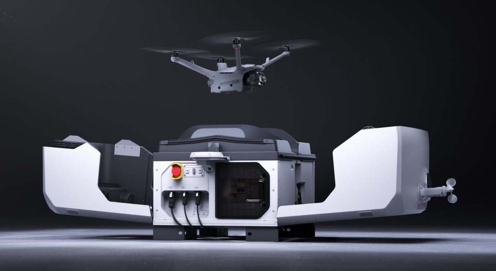
Automated infrastructure monitoring is not powered by a single device. It relies on an integrated ecosystem where mission planning, autonomous deployment, precise data capture, and centralized management work together as one continuous workflow.
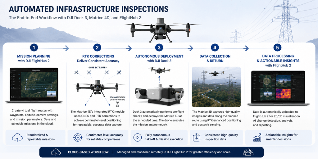
The process begins with DJI FlightHub 2, where operators create virtual flight routes, define inspection parameters, schedule recurring missions, and remotely manage the drone fleet. Once a mission is scheduled, DJI Dock 3 automatically prepares the aircraft for flight by serving as a secure docking station for charging, storage, automated takeoff, and autonomous landing. This eliminates the need to send personnel to the site for every routine inspection.
The inspection itself is carried out by the DJI Matrice 4D, which combines high-resolution imaging, an integrated RTK module for centimeter-level positioning, and advanced obstacle sensing to capture reliable, repeatable inspection data. Because every mission follows the same predefined flight path, organizations can consistently monitor critical assets and compare results over time.
Together, DJI FlightHub 2, DJI Dock 3, and DJI Matrice 4D create a connected ecosystem that automates the entire inspection lifecycle, from mission planning to data collection, while improving efficiency, consistency, and operational visibility.
The next step is understanding how every autonomous mission is planned before the aircraft ever leaves the dock.
Step 1: Mission Planning with DJI FlightHub 2
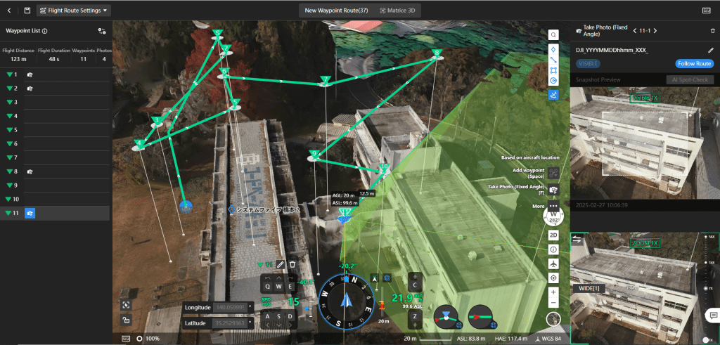
Every autonomous inspection starts with a well-planned mission. To deliver consistent and repeatable results, organizations need a standardized process that can be managed across multiple sites. DJI FlightHub 2 provides a centralized platform for planning, scheduling, and managing automated inspections.
Using DJI FlightHub 2, operators can create Virtual Flight Routes by defining waypoints, flight altitude, speed, camera angles, and inspection targets. These routes can be saved and scheduled to run automatically, ensuring every inspection follows the same flight path and captures data from consistent viewpoints.
As a cloud-based platform, FlightHub 2 also enables remote mission management, fleet monitoring, and access to flight records from a centralized location. When a scheduled mission begins, DJI Dock 3 automatically prepares the DJI Matrice 4D for deployment, allowing inspections to be performed with minimal on-site intervention.
Standardized mission planning not only reduces manual workload but also produces consistent datasets that make long-term infrastructure monitoring more reliable.
Following the same route is only part of the process. To compare inspection data accurately over time, every flight must also maintain precise positioning.
Step 2: RTK Corrections Deliver Consistent Accuracy
Repeatable flight routes are only effective when the aircraft can return to nearly the exact same position during every mission. This is where Real-Time Kinematic (RTK) technology becomes essential.
The DJI Matrice 4D features an integrated RTK module that works with multi-constellation GNSS satellite systems to achieve centimeter-level positioning accuracy. By receiving correction data from a compatible RTK base station or network, the aircraft can consistently follow the same virtual flight route created in DJI FlightHub 2.
This precision allows images and inspection data to be captured from nearly identical viewpoints during every flight, making historical comparisons far more reliable. Asset managers can more easily identify structural changes, vegetation encroachment, equipment deterioration, or construction progress because the data is accurately georeferenced and consistently collected.
With mission planning and RTK-enhanced positioning in place, the inspection workflow is ready for autonomous execution, allowing DJI Dock 3 to deploy, recover, and prepare the aircraft for its next scheduled mission.
Step 3: Autonomous Deployment with DJI Dock 3
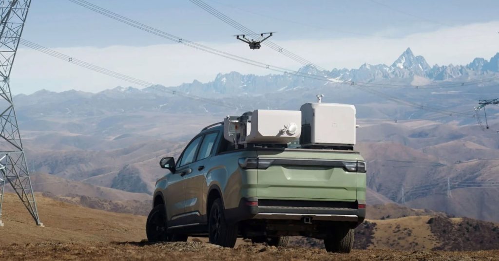
With the mission planned and RTK positioning established, DJI Dock 3 takes over the inspection process. Designed for remote operations, it automates deployment, recovery, and charging, allowing routine inspections to be performed with minimal human involvement.
At the scheduled time, DJI Dock 3 performs automated pre-flight checks before launching the DJI Matrice 4D to execute its assigned virtual flight route. During the mission, the aircraft uses its onboard navigation system, integrated RTK module, and advanced obstacle sensing to safely capture high-quality inspection data while following the predefined flight plan.
Operators can monitor mission progress remotely through DJI FlightHub 2 without traveling to the inspection site. Once the mission is complete, the DJI Matrice 4D autonomously returns to DJI Dock 3, where it lands, recharges, and prepares for the next scheduled operation.
This fully automated workflow reduces travel time, increases inspection frequency, and delivers consistent data collection, enabling organizations to monitor critical infrastructure more efficiently while freeing personnel to focus on higher-value tasks.
The true advantage, however, lies in how this consistent stream of inspection data supports faster, smarter maintenance decisions.
Traditional vs Automated Infrastructure Monitoring
| Aspect | Traditional Drone Inspections | Automated Monitoring with DJI Dock 3 & DJI Matrice 4D |
| Mission Planning | Manual planning before every flight | Predefined missions scheduled in DJI FlightHub 2 |
| Deployment | Pilot travels to the site and launches the drone | DJI Dock 3 performs autonomous takeoff and deployment |
| Position Accuracy | Standard GNSS positioning | Integrated RTK module with centimeter-level positioning |
| Inspection Consistency | Flight paths vary between pilots | Repeatable virtual flight routes for consistent data |
| On-site Personnel | Pilot required for every inspection | Remote mission execution with minimal on-site presence |
| Data Collection | Manual flight and image capture | Automated image capture following predefined routes |
| Data Review | Manual comparison of inspection data | FlightHub 2 supports AI change detection and historical comparison |
| Operational Efficiency | More travel time and labor are required | Automated workflows reduce operational workload |
| Maintenance Strategy | Reactive maintenance after issues are found | Proactive maintenance based on recurring inspection data |
Turning Inspection Data into Actionable Intelligence
Automating inspections is only the first step. The real value lies in turning consistent inspection data into actionable insights that support faster and more informed maintenance decisions.
Because every mission follows the same virtual flight route with RTK-enhanced positioning, organizations can compare inspection results over time with greater confidence. DJI FlightHub 2 further streamlines this process with tools such as AI Change Detection, helping operators quickly identify changes that may require attention instead of manually reviewing large volumes of imagery.
This enables infrastructure owners to detect vegetation encroachment along power lines, monitor structural changes to bridges, assess the condition of solar installations, or track construction progress with greater consistency. Rather than reacting to unexpected failures, maintenance teams can identify developing issues earlier, prioritize repairs, and allocate resources more effectively.
By combining autonomous deployment, precise positioning, and intelligent data analysis, DJI Dock 3, DJI Matrice 4D, and DJI FlightHub 2 help organizations move from reactive inspections to a proactive infrastructure monitoring strategy.
The result is greater operational efficiency, improved asset reliability, and better long-term decision-making.
The Future of Infrastructure Monitoring Is Autonomous
Infrastructure monitoring is evolving beyond manual inspections and isolated drone flights. As organizations manage larger networks of critical assets, the ability to automate routine inspections has become essential for improving efficiency, maintaining safety, and making better-informed operational decisions.
By combining DJI FlightHub 2, DJI Dock 3, and DJI Matrice 4D, organizations can create an end-to-end automated monitoring workflow. FlightHub 2 streamlines mission planning and remote fleet management, the DJI Matrice 4D captures high-quality inspection data with RTK-enhanced positioning, and DJI Dock 3 enables autonomous deployment, recovery, and charging. Together, these technologies deliver consistent, repeatable inspections with minimal on-site intervention.
The result is a smarter approach to infrastructure management that reduces operational workload, increases inspection frequency, and provides the reliable data needed for proactive maintenance planning. Whether monitoring utilities, transportation networks, energy facilities, or construction projects, automated drone operations help organizations respond to changes before they become costly problems.

Ready to Automate Your Infrastructure Monitoring?
Whether you’re managing power infrastructure, transportation networks, energy facilities, or large-scale construction projects, the DJI Dock 3 with DJI Matrice 4D offers a smarter way to perform routine inspections. By combining autonomous deployment, RTK-enhanced accuracy, and centralized mission management through DJI FlightHub 2, your team can improve operational efficiency while gaining reliable, actionable insights.
Explore the DJI Dock 3 with DJI Matrice 4D and contact Dynatech Innovations today to learn how an automated drone ecosystem can help streamline your infrastructure monitoring operations.