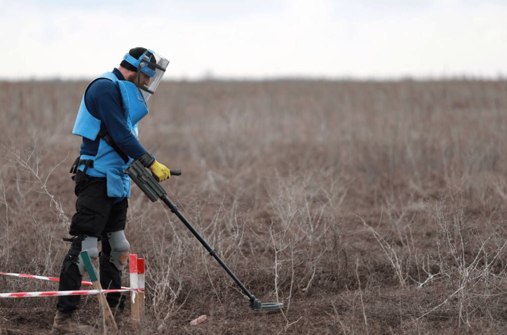
Unexploded ordnance doesn’t announce itself. It waits. And for decades, the only reliable way to find it was to put trained personnel directly in harm’s way and hope the methodology held. Traditional ground-based surveys are slow, physically demanding, and carry an inherent risk that no safety protocol can fully eliminate.
The technology to change this already exists, and it’s being used right now in some of the world’s most demanding environments. Drone-mounted magnetometry is rapidly augmenting manual detection methods, covering large areas faster and mapping subsurface anomalies with precision. At the center of this shift is a powerful pairing: the DJI Matrice 400 and the MagNIMBUS Atomic Total-Field Magnetometer. Together, they don’t just improve the survey process. They fundamentally rethink how it’s done.
Why Traditional UXO and Subsurface Detection Falls Short
Ground surveys have been the standard for decades, and for good reason: metal detectors and magnetometers work, trained personnel know how to use them, and the methodology is well understood. But the limitations are hard to ignore once you’ve seen them play out in the field.
Walking a detector over a minefield or a suspected UXO zone means someone has to be there. Every step is a calculated risk, and in areas with dense vegetation or unstable soil, that risk compounds quickly. A two-person team carrying a large-loop detector might cover a few hundred square meters in a full day. Scale that up to a post-conflict agricultural area or a pipeline corridor and you’re looking at years of work before the site is even considered safe.
Fatigue leads to gaps. Gaps lead to missed anomalies. Something had to give. And the answer came from above.
Meet the Hardware: DJI Matrice 400
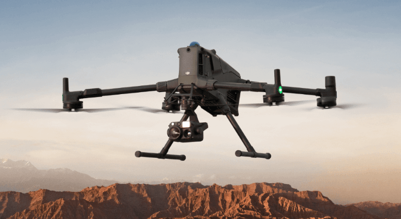
In UAV magnetometer surveys, the sensor drives the mission requirements, and the aerial platform must be capable of supporting those requirements in the field. Long flight endurance, stable low-altitude performance, payload capacity, and operational reliability all play an important role in ensuring consistent magnetic data collection. This is where the DJI Matrice 400 stands out.
Designed for demanding enterprise operations, the Matrice 400 provides the endurance, stability, and robustness needed for advanced geophysical missions. With a payload capacity of up to 6 kg, it can comfortably carry the MagNIMBUS magnetometer system while maintaining reliable flight performance.
Its extended flight time of up to 59 minutes enables efficient coverage of large survey areas, reducing interruptions and improving productivity. The platform is also built for challenging environments, featuring an IP55 weather resistance rating, a wide operating temperature range, integrated LiDAR and mmWave radar for obstacle awareness, and O4 Enterprise transmission for dependable connectivity.
Together, these capabilities make the DJI Matrice 400 a reliable platform for supporting high-precision aerial magnetometry in complex and high-risk environments.
Meet the Sensor: MagNIMBUS Atomic Total-Field Magnetometer
The drone gets you there safely. The MagNIMBUS is what actually finds what’s buried.
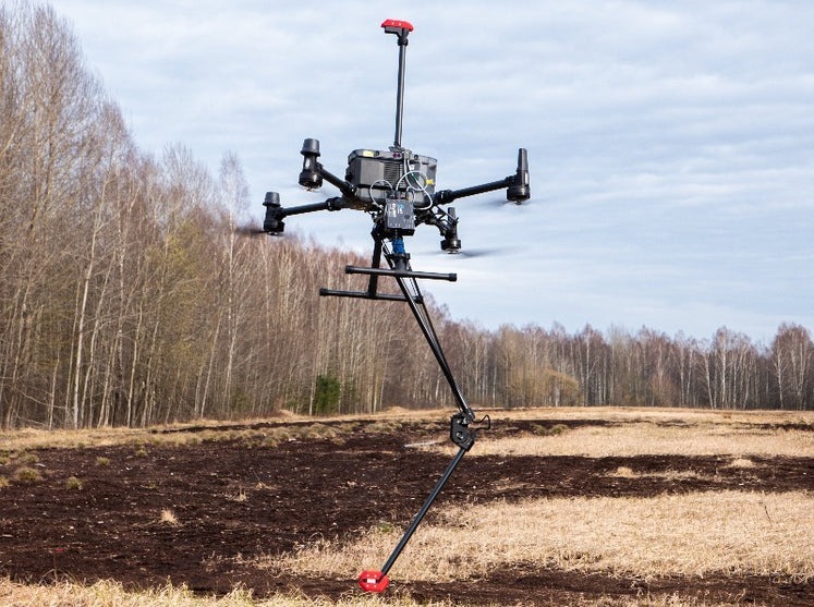
Powered by QuSpin Gen-2 atomic sensors, the MagNIMBUS is an ultra-sensitive total-field magnetometer built from the ground up for airborne survey work. It comes in two configurations: the vertical gradiometer setup, which uses two sensors to simplify data processing and makes possible surveys near powerlines, railroads or other sources of EM noise, and the single-sensor foldable mount configuration, better suited for teams with experienced data processing specialists on hand.
The self-foldable sensor mount allows normal takeoff and landing without special rigging, and the system is built to fly at extremely low surface clearance, sometimes just centimeters above the ground. That low altitude is critical for detecting smaller items like fragmentation grenades, where the sensor needs to be within roughly a meter of the target. If the sensor grazes vegetation during a pass, the drone stays in the air, which changes how you can operate in dense or overgrown terrain.
Detection range scales with target size, from hand grenades at around 1 meter to large aerial bombs at several meters. One important limitation: the MagNIMBUS detects ferrous metal casings and cannot confirm an area is completely clear. It is best used as part of a structured Non-Technical or Technical Survey workflow, not as a standalone detection tool.
How the System Works Together
Knowing the hardware is one thing. Seeing how it operates as a complete system is another.
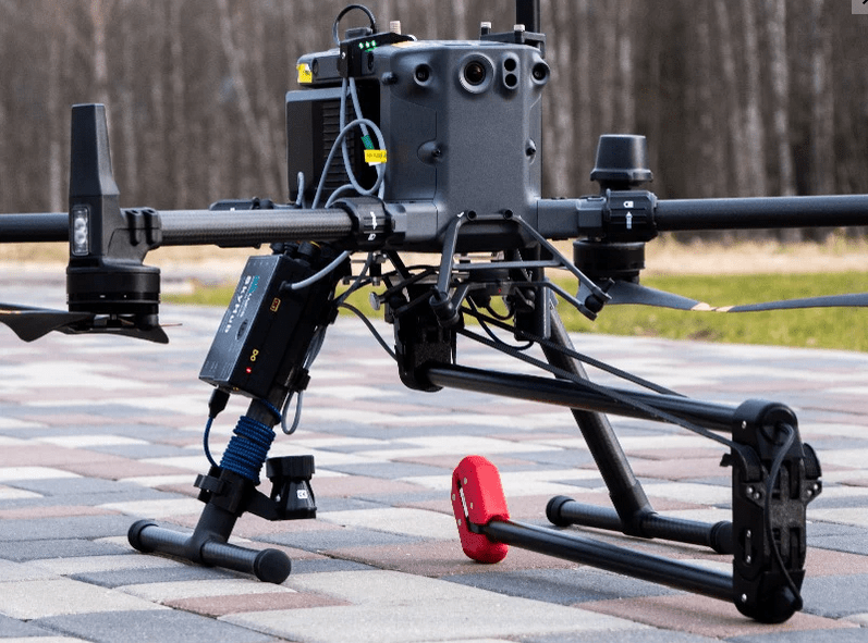
The MagNIMBUS mounts directly onto the DJI Matrice 400 with a standard kit that includes all necessary mountings and cables. Once airborne, the SkyHub onboard computer logs magnetic field data in real time while managing terrain-following mode, keeping the sensor at a consistent low altitude over uneven ground throughout the entire survey.
Flight paths are planned through the included UgCS Expert software, laying out precise grid patterns that ensure full area coverage with no gaps. Post-mission data can be processed using several industry tools, Geosoft Oasis Montaj remains the recommended choice given its robust handling of large geophysical datasets and wide adoption across UXO and mineral exploration industries.
The workflow from pre-flight planning to processed output is repeatable, systematic, and built for the field.
Real-World Applications
UXO clearance is the most obvious application, but it’s far from the only one.
The same combination of precise flight control and atomic-grade magnetic sensitivity translates directly into other high-value survey work. Locating buried metal pipes and shielded or powered cables becomes significantly faster when you can cover large infrastructure corridors from the air. Environmental surveys for abandoned wells, underground storage tanks, and decommissioned pipelines follow the same logic. The target is ferrous, the ground is the obstacle, and the drone removes that obstacle entirely.
In mining, the system detects tramp metals and lost ground engagement tools that are potentially dangerous to processing equipment. In geology and mineral prospecting, the MagNIMBUS captures regional magnetic field variations that inform exploration decisions before a single drill goes into the ground. Even archaeology benefits, giving researchers a non-invasive way to identify subsurface structures without disturbing the site.
Why This Combination Wins in High-Risk Environments
The individual strengths of each component are clear, but the real value of this system is what happens when they work together in the field.
The Matrice 400 brings the endurance, payload capacity, and environmental toughness to operate where conditions are rarely ideal. The MagNIMBUS brings the sensitivity and design resilience to extract reliable data from those same places. Paired together, they cover each other’s gaps in a way that makes the whole system greater than the sum of its parts.
Safety is the most immediate benefit, with operators staying well clear of hazardous ground while the drone does the work. Speed follows closely behind. What used to take weeks of ground survey work can now be completed in days, with consistent results and a digital output ready for analysis.
For organizations in high-risk environments, that combination of safety, speed, and accuracy is often the difference between a project that moves forward and one that doesn’t.
Where Safety and Precision Meet
Drone-based magnetometry has moved well past the experimental stage. The DJI Matrice 400 and MagNIMBUS represent a mature, field-proven approach to hazardous environment surveying, and the results speak for themselves: faster coverage, safer operations, and data quality that holds up under professional scrutiny.
If your organization is dealing with UXO clearance, subsurface mapping, or survey work where ground access is limited or dangerous, this system is worth a serious look.
Dynatech Innovations supplies both products along with a full range of enterprise drone solutions and survey equipment. Visit www.dynatech.ae to explore the full range, request a demo, or get in touch for a tailored quote.