Back

Out of stock
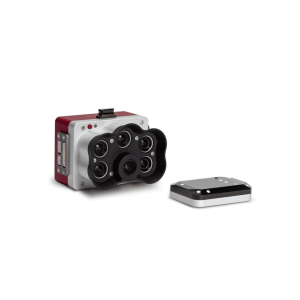
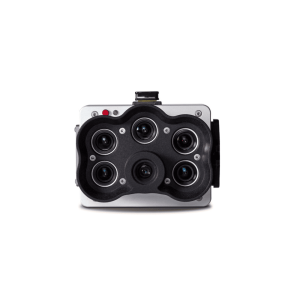
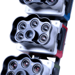
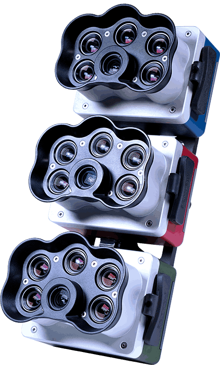
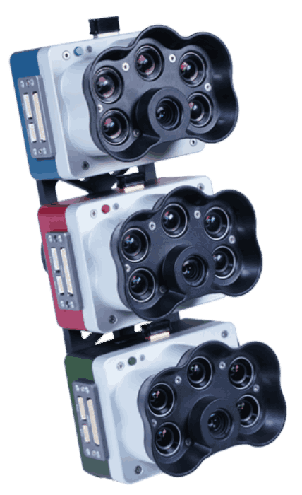
MicaSense RedEdge-P Triple
Key Features
- Single, dual, or triple setups for up to 15 multispectral spectral bands.
- Pan-sharpening technology for spatial resolution of 2 cm / 0.8 in
- Multiple rededge bands for advanced stress analysis.
- Double radiometric calibration with light sensor and calibration reflectance panel
- Narrow bands for enhanced data accuracy.
- Fast capture rate: 3 raw DNG images per second.
- Synchronized capture of all 15-bands
- RTK enabled
Contact us for more information
-
Description
Precision superspectral imaging supporting agronomy and ecology, from seedling to harvest.
High-resolution multispectral drone sensors for plant classification, weed identification, environmental research and conservation, and digital plant phenotyping
Benefits
- Perform detailed analysis on carotenes and antrocyanin by using indices like PRI, ARI & CRI.
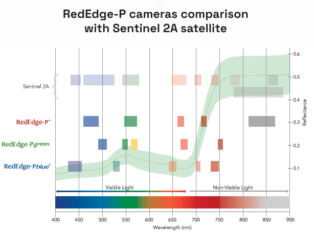
- Obtain imagery comparable to Landsat and Sentinel satellite data at an enhanced resolution.
- Perform detailed analysis on chlorophyll efficiency and identify weeds.
- Conduct reliable time-series analysis even in varying light conditions.
- Enable accurate crop counting in early growth stages using machine learning and AI.
- Generate insights beyond what the eye can see with multiple outputs and indices such as RGB, NDVI, NDRE, OSAVI, PSRI and DSM.
- Work with the equipment you already have – compatible with most professional drone platforms such as DJI and Pix4D.
- With a total of 4 bands in the rededge spectrum, more biophysical parameters can be distinguished
APPLICATIONS
Crop Health Analysis
Monitor chlorophyll levels, detect stress early, and evaluate crop health to optimize treatment.
Advanced Pigment Detection
Track Carotenoid and Flavenoid content to optimise flavour and crop maturity.
Species Identification
Differentiate crops from weeds, identify invasive species, and enable targeted field management.
Ecosystem Resource Surveillance
Track vegetation changes, soil conditions, and water availability for sustainable land conservation.
Coastal Habitat Mapping
Map near-shore ecosystems, detect algae blooms and aquatic vegetation across tidal zones and wetlands.
Specifications
| Weight | 1080 gr / 38 oz (including mounting hardware, DLS2, and cable) |
| Dimensions | 21.9 cm x 11.4 cm x 9 cm / 8.6 in × 4.5 in × 3.5 in |
| RGB output | 5.1 MP* (global shutter, aligned with all bands) |
| Sensor resolution | 1456 x 1088 (1.6 MP per multispectral band) 2464 x 2056 (5.1 MP panchromatic band) |
| Ground sample distance | 7.7 cm / 3 in per pixel (per multispectral band) at 120 m / ~400 ft AGL 3.98 cm / 1.5 in per pixel (panchromatic band) at 120 m / ~400 ft AGL |
| Field of view | 50° HFOV x 38° VFOV (multispectral), 44° HFOV x 38° VFOV (panchromatic) |
| Capture rate | Up to 3 images per second raw DNG |
| Storage | CFexpress card |
| Interfaces | Three configurable GPIO: select from trigger input, PPS input, PPS output, and top of frame signals. Host virtual button. USB 2.0 port for WiFi. Serial. 10/100/1000 Ethernet. |
| External power | 7.0 V – 25.2 V |
| Power input | 11/14.0/20W (standby, average, peak) |
| Heat | Ambient without airflow: 0-40 °C / 0-104 °F Ambient with airflow >0.5 meter per second / >1.1 mph: 0-50 °C / 0-122 °F |
| IP rating | IP4X |
Included in the box:
- RedEdge-P, RedEdge-P blue and RedEdge-P green cameras
- DLS 2 light sensor with embedded GPS
- CRP2 Calibrated Reflectance Panel
- USB Wi-Fi dongle
- Lens cover
- Integration cables
- Assorted mounting hardware for dual and triple uses
- CFexpress card
- CFexpress card reader
- Hard carrying case
- Start guide