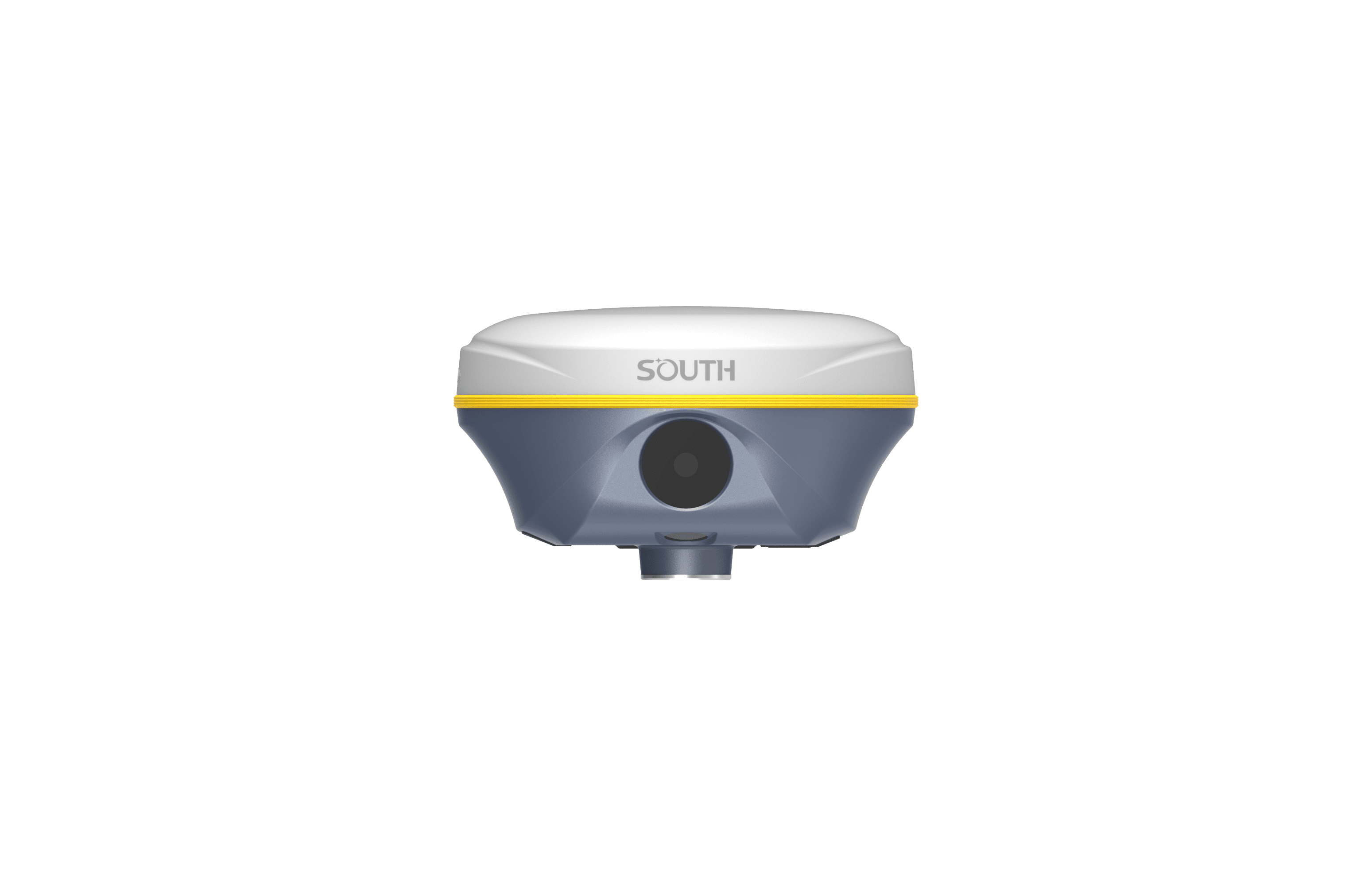

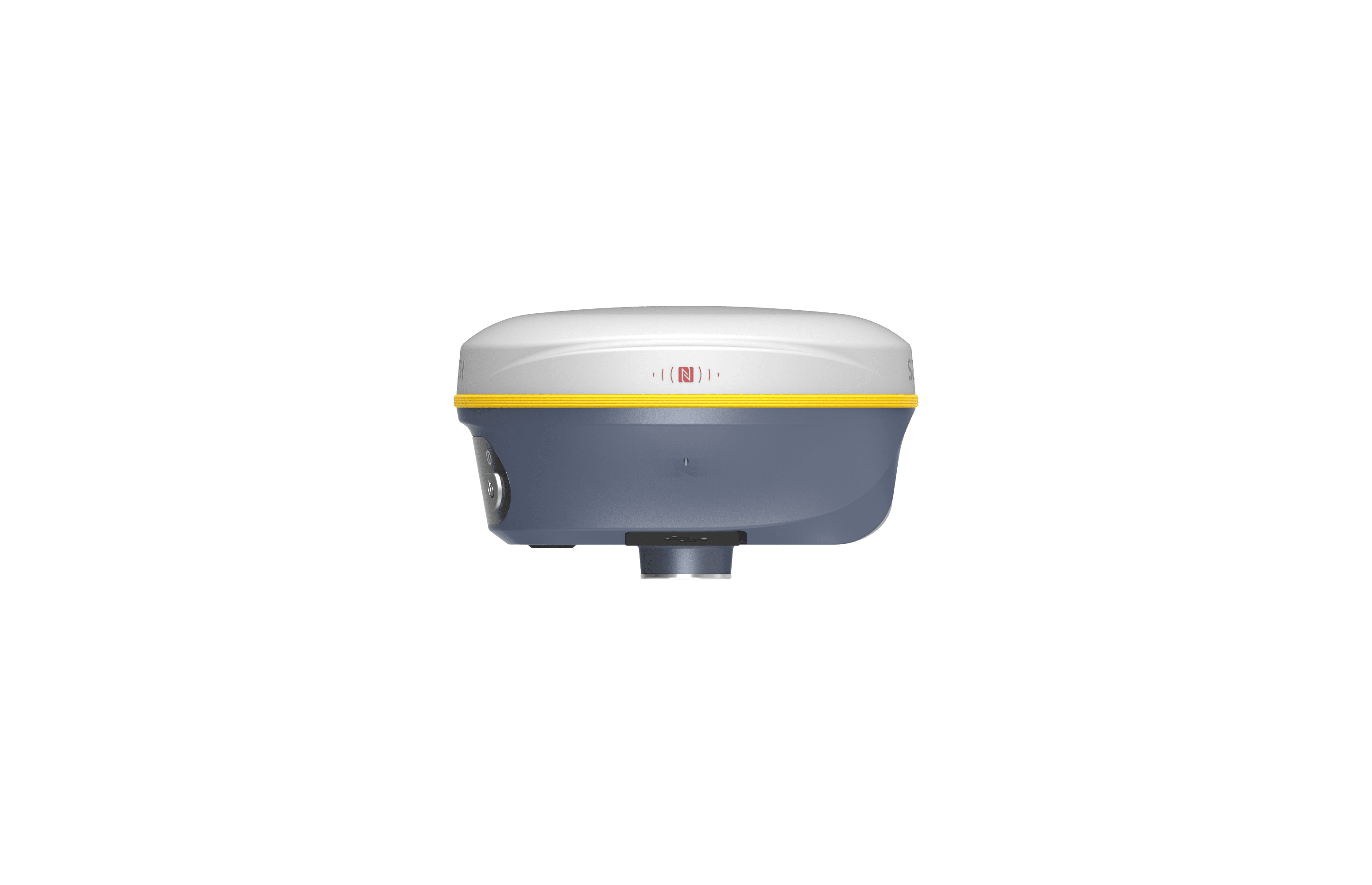
South V3
VISUAL POSITIONING RTK
- Dual Camera Visual Positioning
- Dual Camera AR Stakeout
- 3D Modeling by Video Shooting
- A Few of Ways for Data Processing
- 1698 channels S805 Inside
- Dual-Engine Algorithm
- Farlink 2.0 Radio
- 5th generation IMU
-
Description
Five New Features
— To Give You More Productivity
S805, the New Pop Star
Save Weak Signal
SOUTH S805 has 1698 channels to track more satellites and weak signals.
The success rate and speed of obtaining a fixed solution has been greatly improved. Under the dense forest and surrounded by buildings, it just takes tens of seconds to get a fixed solution.
Farlink 2.0 Radio
More Performance
When compared with the last generation Farlink, V3‘s Farlink 2.0 radio can undertake larger data and provide more stable transmission, working range is as far as 10-12 km in ideal condition.
With the “lock-base” function, V3 can keep receiving data from one specific base. Even though several bases are transmitting with the same frequency.
Dual Camera AR Stakeout
Extra Convenience
V3 allows you to use both of front camera and bottom camera to stakeout points, lines, curves.
The AR guideline on controller app will indicate you to go to the correct direction since you are tens of meters away from the target.
The 5th Gen. IMU
New Experience
The latest update of IMU effectively eliminates the loss of Inertial-Measurement-Usable Status in the majority of scenarios, enhancing IMU availability and roductivity.
During AR stakeout, visual positioning and 3D modeling collection, you can walk at your own pace without worrying about losing IMU, making workflow smooth.
Dual-Engine GNSS
Positioning Algorithm
Unlike traditional GNSS receivers, the V3 is equipped with two different positioning algorithms.
When users encounter inaccurate VRS RTK positioning due to unusually active ionospheric conditions, they can enable the second set of algorithms in the software to correct errors in real-time and improve measurement accuracy. (by selecting Enhanced Positioning Mode in the SurvStar app.)
Specification
| GNSS Features | Channels | 1698 |
| GPS | L1C, L1C/A, L2C, L2P(Y), L5 | |
| GLONASS | G1, G2, G3 | |
| BDS | B1I, B2I, B3I, B1C, B2a, B2b | |
| GALILEOS | E1, E5a, E5b, E6, AltBOC* | |
| SBAS(WAAS/MSAS/EGNOS/GAGAN) | L1* | |
| IRNSS | L5* | |
| QZSS | L1, L2C, L5* | |
| MSS L-Band* | BDS-PPP, GALILEO-HAS | |
| Positioning output rate | 1Hz~20Hz | |
| Initialization time | < 10s | |
| Initialization reliability | > 99.99% | |
| Positioning Precision | Code Differential Positioning |
Horizontal: 0.25 m + 1 ppm RMS Vertical: 0.50 m + 1 ppm RMS |
| GNSS static | Horizontal: 2.5 mm + 0.5 ppm RMS Vertical: 3.5 mm + 0.5 ppm RMS |
|
| Static (Long Observation) | Horizontal: 2.5 mm + 0.1 ppm RMS Vertical: 3 mm + 0.4 ppm RMS |
|
| Rapid Static | Horizontal: 2.5 mm + 0.5 ppm RMS Vertical: 5 mm + 0.5 ppm RMS |
|
| PPK | Horizontal: 3 mm + 1 ppm RMS Vertical: 5 mm + 1 ppm RMS |
|
| RTK (UHF) | Horizontal: 8 mm + 1 ppm RMS Vertical: 15 mm + 1 ppm RMS |
|
| RTK ( NTRIP) | Horizontal: 8 mm + 0.5 ppm RMS Vertical: 15 mm + 0.5 ppm RMS |
|
| SBAS Positioning | Typically<5m 3DRMS | |
| RTK Initialization Time | 2~8s | |
| IMU Tilt Angle | 0°~60° | |
| Hardware Performance | Dimension | 134mm(φ)×79.1mm(H) |
| Weight | 860g (battery included) | |
| Material | Magnesium aluminum alloy shell | |
| Operating Temperature | -45℃~+75℃ | |
| Storage Temperature | -55℃~+85℃ | |
| Humidity | 100% Non-condensing | |
| Waterproof/Dustproof | IP68 standard, protected from long time immersion to depth of 1m IP68 standard, fully protected against blowing dust |
|
| Shock/Vibration | Withstand 2 meters pole drop onto the cement ground naturally | |
| Power Supply | 6-28V DC, overvoltage protection | |
| Battery | Inbuilt 6800mAh rechargeable Lithium-ion battery | |
| Battery Life | 25h (rover mode) | |
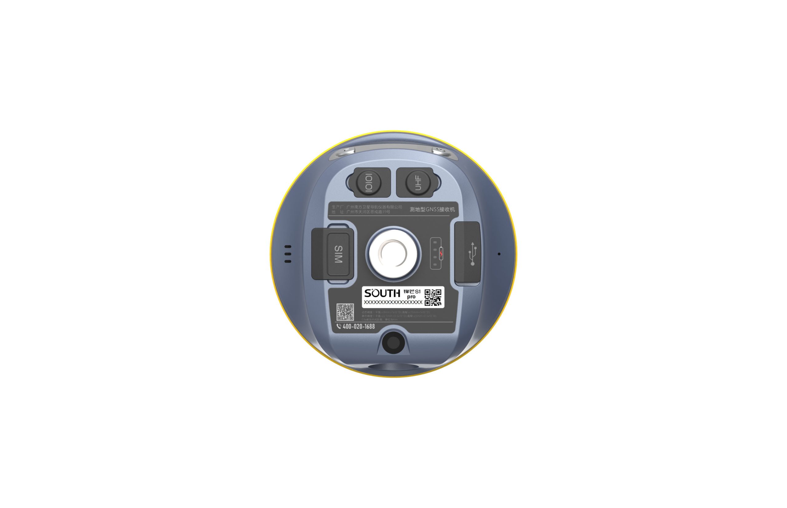
| Communications | I/O Port | 5-PIN LEMO interface (external power port + RS232) Type-C interface (charge+OTG+Ethernet) UHF antenna interface SIM card slot (Micro SIM) |
| Internal UHF | Radio receiver and transmitter | |
| Frequency range | 410-470MHz | |
| Communication protocol | Farlink, Trimtalk, SOUTH, HUACE, Hitarget, Satel | |
| Communication range | Typically 8km with Farlink protocol | |
| Cellular Mobile Network | 4G | |
| Bluetooth | Bluetooth 3.0/4.1 standard, Bluetooth 2.1 + EDR | |
| NFC Communication | Support | |
| Modem | 802.11 b/g/n standard | |
| Data Storage/Transmission | Storage | 16GB SSD internal storage Automatic cycling storage Support external USB storage (OTG) The customizable sample interval is up to 20Hz |
| Data Transmission | Plug and play mode of USB data transmission Supports FTP/HTTP data download |
|
| Data Format | Static data format: STH, Rinex2.01, Rinex3.02 and etc. Differential data format: RTCM 2.1,RTCM 2.3, RTCM 3.0, RTCM 3.1,RTCM 3.2 GPS output data format: NMEA 0183, PJK plane coordinate, Binary code Network model support: VRS, FKP, MAC, fully support NTRIP protocol |
|
| Sensors | IMU | Built-in IMU module, calibration-free, 60° |
| Camera | Visual positioning camera: 8MP (can be used in AR stakeout) AR stakeout camera: 2MP | |
| Electronic Bubble | Controller software can display electronic bubble, checking leveling status of the carbon pole in real-time | |
| Thermometer | Built-in thermometer sensor, adopting intelligent temperature control technology, monitoring and adjusting the receiver temperature | |
| User Interaction | Operating system | Linux |
| Buttons | Dual button | |
| Indicators | Satellites, data and power indicators | |
| Web Interaction | With access to Web UI via WiFi or USB connection, users can monitor the receiver status and change the configurations | |
| Voice Guidance | Chinese/English/Korean/Spanish/ Portuguese/Russian/Turkish/French/ Italian | |
| Secondary Development | Provides secondary development package, and opens the OpenSIC observation data format and interaction interface definition | |
| Cloud Service | The powerful cloud platform provides online services like remote management, firmware updates, online registers, etc. |
*Reserve for future upgrade.
Remarks: Measurement accuracy and operation range might vary due to atmospheric conditions, signal multipath, obstructions, observation time, temperature, signal geometry and number of tracked satellites. Specifications subject to change without prior notice.
1.Actual battery life can vary depending on usage patterns and other factors. The listed parameter was obtained under controlled testing conditions.
Related products
-
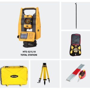
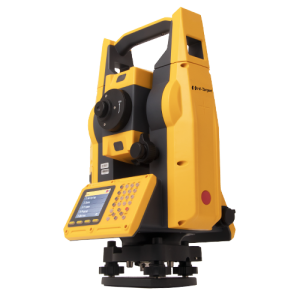
Hi-Target HTS 521L10 Optical Total Station (Full Set)
$3,158.91 VAT Excl -
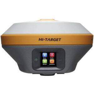
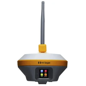
Hi-Target iRTK5 GNSS RTK System
$3,131.68 VAT Excl -