-
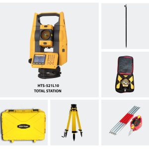
1× AED12,725.00
Subtotal: AED12,725.00
Subtotal: AED12,725.00

AED22,860.00 VAT Excl
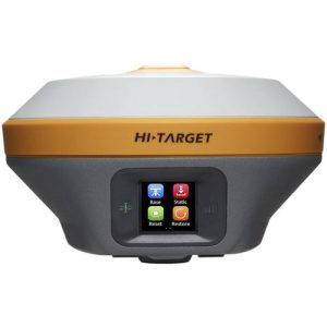
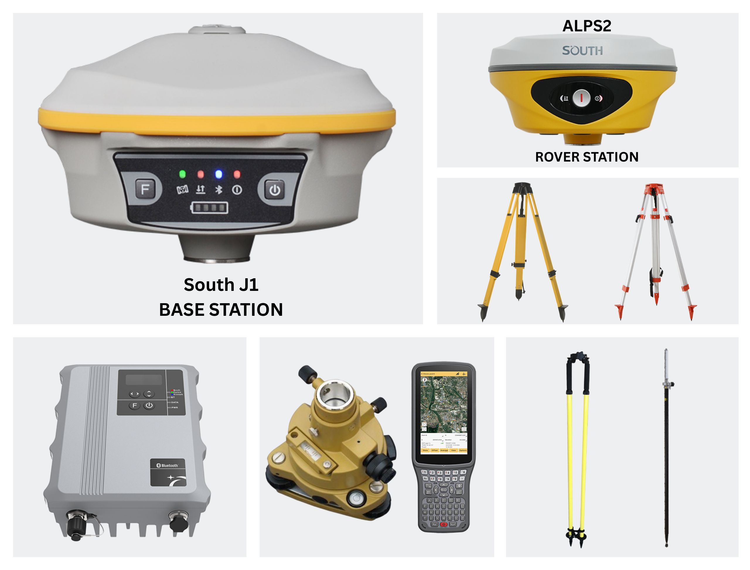
South J1
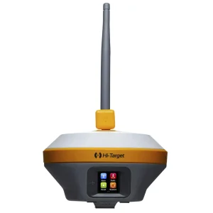
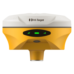
South ALPS 2
J1 is designed to enhance your performance in the field survey and to provide the most reliable positioning result.
It integrates a 1598 channels world leading GNSS positioning engine, high precision IMU, long range UHF radio and new interact operating system.
More features are to be discovered by you…
With 1598 GNSS channels solution, J1 can support multi-constellation and multifrequency tracking with the help of high-performance GNSS antenna.
Coupling a high-performance UHF module with Farlink communication technology,
which increases signal sensitivity and transmission efficiency, J1 really achieves the goal
of a 8~15km ultra-long-distance working range. And the power consumption of this
carrying new generation module is 60% lower than additional UHF, making the Base
working time is much longer.
J1 uses a built-in 10000mAh ultra-large capacity Li-ion battery, which can last 25
hours of continuous work (Static) benefits from low power consumption circuit design.
The Type-C interface is used on J1 that it can support fast charging through a charger
with PD protocol, and it can be full charged in 4 hours.
The measured data can be simultaneously stored into both internal memory of
receiver and controller, realizing the measured data double backup, which effectively
avoid data loss.
Built-in 4th-generation IMU automatic compensator corrects the coordinates to the
pole tip, assisting surveyors to quickly and accurately measure or stake out point at will
without strictly leveling the receiver, the tilt angle range can achieve up to 60°.
Upward UHF antenna design, achieving all-direction UHF signal receiving and
transmitting. And the antenna interface is hidden into top cover that effectively avoid
accident breaking, protect from water and dust.
Using one-to-one signal tracking and locking technology, and the independent
frequency under Farlink protocol, the J1 rover can continuously lock and capture the
target base station signal to reduce cross-frequency interference even though other
base stations are working nearby with the same channel.
J1 is integrated with the ROS system, which comes with intelligent deployment of
multi-mode hardware components, strong computing power and an intelligent
scheduling mechanism, and coupling with an ultra-fine memory management
mechanism, making the fluency and running speed of the receiver comprehensively
improved.
| GNSS Features | Channels | 1598 |
| GPS | L1C/A, L2C, L2P, L5 | |
| GLONASS | G1, G2, G3*(reserved) | |
| BDS | B1I, B1C, B2I, B2a, B3 | |
| GALILEO | E1, E5A, E5B, E5AltBOC, E6 | |
| SBAS | EGNOS, WAAS, GAGAN, MSAS, SDCM(L1,L5) | |
| QZSS | L1C/A, L1C, L2C, L5, L6 | |
| Navic On module L-Band (Reserve) | L5*(reserved) | |
| Positioning output rate | 1Hz~20Hz | |
| Initialization time | < 10s | |
| Initialization reliability | > 99.9% | |
| Positioning Precision* | Real-time kinematic (Baseline<40km) | Horizontal: 8 mm + 0.5 ppm RMS |
| Vertical: 15 mm + 1 ppm RMS | ||
| GNSS Static | Horizontal: 2.5 mm + 0.5 ppm RMS | |
| Vertical: 5 mm + 0.5 ppm RMS | ||
| Standalone | Horizontal: 1.2m Vertical: 1.9m RMS | |
| DGNSS | Horizontal: 0.4m Vertical: 0.7m RMS | |
| SBAS positioning | Horizontal: 0.6m Vertical: 0.8m RMS | |
| IMU tilt compensation | typically less than 10mm + 0.7 mm/° tilt down to 30° | |
| IMU tilt angle | 0° ~ 60° | |
| Hardware Performance | Dimension | 165mm(φ) × 108mm(H) |
| Weight | 1.35kg (battery included) | |
| Material | Magnesium aluminum alloy shell | |
| Operating temperature | -45℃ ~ +65℃ | |
| Storage temperature | -45℃ ~ +85℃ | |
| Humidity | 100% Non-condensing | |
| Waterproof/Dustproof | IP68 standard, protected from long time immersion to depth of 1m IP68 standard, fully protected against blowing dust |
|
| Shock/Vibration | Withstand 2 meters pole drop onto the cement ground naturally | |
| Power supply | 9-28V DC, overvoltage protection | |
| Battery | Inbuilt 10000mAh rechargeable, unremovable Li-ion battery | |
| Battery life* | Static: 20~25hrs Base: 10~12hrs Rover: 16~20hrs |
|
| Camera | 2 MP | |
| FOV | 75° | |
| WIFI | Modem | 802.11 b/g standard |
| WIFI hotspot | Receiver broadcasts its hotspot form web UI accessing with any mobile terminals | |
| Communications | I/O Port | 5-PIN LEMO external power port + RS232 Type-C interface (charge + OTG + Ethernet) 1 UHF antenna interface 1 PPS ouput interface SIM card slot (Micro SIM) |
| Internal UHF | 3W receiver and transmitter | |
| Frequency range | 410 – 470MHz | |
| Communication protocol | Farlink, Trimtalk450s, SOUTH, HUACE, Hi-target, Satel | |
| Communication range | Typically 8-15km with Farlink protocol | |
| Cellular mobile network | 4G cellular module standard | |
| Bluetooth | Bluetooth 4.2 standard, Bluetooth 2.1 + EDR | |
| NFC Communication | Realizing close range (shorter than 10cm) automatic pair between receiver and controller |
|
| Data Storage/Transmission | Storage | 16GB SSD internal storage standard, extendable up to 64GB |
| Automatic cycle storage | ||
| Support external USB storage | ||
| The customizable sample interval is up to 20Hz | ||
| Data transmission | Plug and play mode of USB data transmission | |
| Supports FTP/HTTP data download | ||
| Static Data format | STH, Rinex2.x, Rinex3.x | |
| Differential data format | CMR, RTCM 2.x, RTCM 3.x(MSM included) | |
| Position output data format | NMEA 0183, PJK plane coordinate, SBF | |
| Network model supports | Fully support NTRIP protocol | |
| Sensors | Electronic bubble | Controller software can display electronic bubble, checking leveling status of the carbon pole in real-time |
| IMU | Built-in IMU module, calibration-free and immue to magnetic interference | |
| Thermometer | Built-in thermometer sensor, adopting intelligent temperature control technology, monitoring and adjusting the receiver temperature | |
| User Interaction | Operating system | Linux |
| Buttons | Dual button | |
| Indicators | 3 LED indicators | |
| Web interaction | With the access of the internal web interface management via WiFi or USB connection, users are able to monitor the receiver status and change the configurations freely |
|
| Voice guidance | It provides status and operation voice guidance | |
| Secondary development | Provides secondary development package, and opens the OpenSIC observation data format and interaction interface definition |
*The data comes from the SOUTH GNSS Product Laboratory, and the specific situation is subject to local actual usage.
With laser measurement, ALPS2 has a broader working range and fewer blind spots, enabling remote measurements in areas with poor GNSS signal quality. Previously challenging spots, like spaces under rooftops and areas with obstacles, are now easily measurable.
Laser measurement allows surveyors to collect target point at a dark environment such as night or semi-indoor environment. It also can measure distance indoor.
Laser measurement allows surveyors to collect target point at a position that traditional RTK can not reach directly, such as point on the surface of a wall, a tree, or sill of window, and the small space that surveyors can not step in.
Laser Measurement help users mitigate risks when surveying near hazardous areas, such as busy roads and sea or lakes, ensuring surveyors’ safety. A secure working approach is not only a personal requirement but also essential for the well-being of your family.
| GNSS Features | Channels | 1698 |
| GPS | L1C, L1C/A, L2C, L2P(Y), L5 | |
| GLONASS | G1, G2, G3 | |
| BDS | B1I, B2I, B3I, B1C, B2a, B2b | |
| GALILEOS | E1, E5a, E5b, E6, AltBOC* | |
| SBAS | L1* | |
| IRNSS | L5* | |
| QZSS | L1, L2C, L5* | |
| MSS L-Band | Reserve | |
| Positioning Output Rate | 1Hz~20Hz | |
| Initialization Time | < 10s | |
| Initialization Reliability | > 99.99% | |
| Positioning Precision | Code differential GNSS positioning | Horizontal: 0.25 m + 1 ppm RMS |
| Vertical: 0.50 m + 1 ppm RMS | ||
| GNSS Static | Horizontal: 2.5 mm + 0.5 ppm RMS | |
| Vertical: 3.5 mm + 0.5 ppm RMS | ||
| Static (Long Observation) | Horizontal: 2.5 mm + 0.1 ppm RMS | |
| Vertical: 3 mm + 0.4 ppm RMS | ||
| Rapid Static | Horizontal: 2.5 mm + 0.5 ppm RMS | |
| Vertical: 5 mm + 0.5 ppm RMS | ||
| PPK | Horizontal: 3 mm + 1 ppm RMS | |
| Vertical: 5 mm + 1 ppm RMS | ||
| RTK(UHF) | Horizontal: 8 mm + 1 ppm RMS | |
| Vertical: 15 mm + 1 ppm RMS | ||
| RTK(NTRIP) | Horizontal: 8 mm + 0.5 ppm RMS | |
| Vertical: 15 mm + 0.5 ppm RMS | ||
| SBAS Positioning | Typically<5m 3DRMS | |
| RTK Initialization Time | 2~8s | |
| IMU Accuracy | 8mm+0.7 mm/°tilt | |
| IMU Tilt Angle | Optimal accuracy within 60° | |
| Hardware Performance | Dimension | 134mm(φ)×79mm(H) |
| Weight | 860g (battery included) | |
| Material | Magnesium aluminum alloy shell | |
| Operating Temperature | -45℃~+75℃ | |
| Storage Temperature | -55℃~+85℃ | |
| Humidity | 100% Non-condensing | |
| Waterproof/Dustproof | IP68 standard | |
| Shock/Vibration | Withstand 2 meters pole drop onto the cement ground naturally | |
| Power Supply | 6-28V DC, overvoltage protection | |
| Battery | Inbuilt 7.4v 6800mAh rechargeable Lithiumion | |
| battery | ||
| Battery Life*1 | 25h (static) | |
| 20h (rover mode, optimal condition) | ||
| Communications | I/O Port | 5-PIN LEMO interface (external power port + RS232) |
| Type-C interface (charge+OTG+Ethernet) | ||
| UHF antenna interface | ||
| Internal UHF | 2W Radio Tx&Rx | |
| Frequency Range | 410-470MHz | |
| Communication Protocol | Farlink, Trimtalk, SOUTH | |
| Communication Range | Typically 8-10km with Farlink protocol, (12-15km in optimal condition) | |
| Bluetooth | Bluetooth 5.0, Bluetooth 3.0/4.2 standard, Bluetooth 2.1 + EDR | |
| NFC Communication | Support | |
| Modem | 802.11 b/g/n standard | |
| Data Storage/Transmission | Storage | 16GB SSD internal storage |
| Support automatic cycling storage | ||
| Support external USB storage (OTG) | ||
| The customizable sample interval is up to 20Hz | ||
| Data Transmission | Plug and play mode of USB data transmission | |
| Supports FTP/HTTP data download | ||
| Data Format | Static data format: STH, Rinex2.01, Rinex3.02, etc. | |
| Differential data format: RTCM 2.1, RTCM | ||
| 2.3, RTCM 3.0, RTCM 3.1, RTCM 3.2 | ||
| GPS output data format: NMEA 0183, PJK | ||
| plane coordinate, Binary code | ||
| Support: VRS, FKP, MAC, fully support | ||
| NTRIP protocol | ||
| Sensors | IMU | Built-in IMU, calibration-free, 60 Degreest |
| Camera | Front Camera: 8MP, Bottom Camera: 2MP, (Live View AR stakeout) | |
| Laser | 3R green laser, 30m working range | |
| Electronic Bubble | Controller software can display electronic bubble, checking leveling status of the carbon pole in real-time | |
| Thermometer | Built-in thermometer sensor, intelligent temperature control technology, monitoring and adjusting the receiver temperature | |
| User Interaction | Operating System | Linux |
| Buttons | Single button | |
| Indicators | Data and power indicators | |
| Web Interaction | With access to Web UI via WiFi or USB connection, users can monitor the receiver status and change the configurations | |
| Voice Guidance | Chinese/English/Korean/Spanish/Arabic/Portuguese/Russian/Turkish/French/Italian | |
| Secondary Development | Provides secondary development package, and opens the OpenSIC observation data format and interaction interface definition | |
| Cloud Service | The powerful cloud platform provides online services like remote management, firmware updates, online registers, etc. |
*Reserve for future upgrade. Remarks: Measurement accuracy and operation range might vary due to atmospheric conditions, signal multipath, obstructions, observation time, temperature, signal geometry and number of tracked satellites. Specifications subject to change without prior notice.
*1.Actual battery life can vary depending on usage patterns and other factors. The listed parameter was obtained under controlled testing conditions.
Created by Tomsher