
Every year, infrastructure inspections expose workers to significant risks, whether climbing communication towers, accessing bridge undersides, or working near high-voltage power lines. These inspections are essential, but they have traditionally been time-consuming, labor-intensive, and potentially hazardous. Today, utilities, transportation agencies, and industrial operators are transforming this process with unmanned aerial systems that improve safety while completing inspections faster and more efficiently.
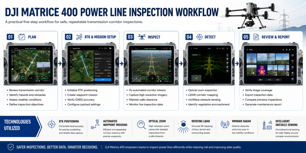
The DJI Matrice 400 is built for these demanding missions, combining long flight endurance, RTK positioning, intelligent obstacle sensing, and support for multiple payloads in a single enterprise platform. However, the aircraft is only one part of a successful inspection. Achieving complete, reliable results depends on selecting the right workflow and sensor configuration for each asset. Power lines, bridges, and communication towers each present unique challenges that require different inspection strategies. Understanding those differences is the key to safer operations and higher-quality inspection data.
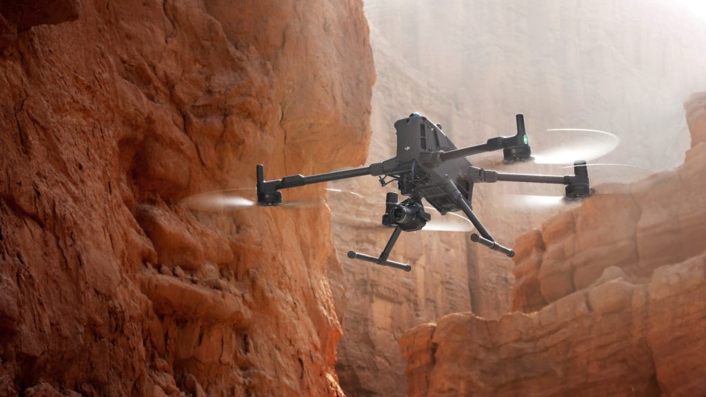
DJI Matrice 400 with Zenmuse H30T | Advanced Drone Inspection Solution
Why Infrastructure Inspections Need Different Workflows
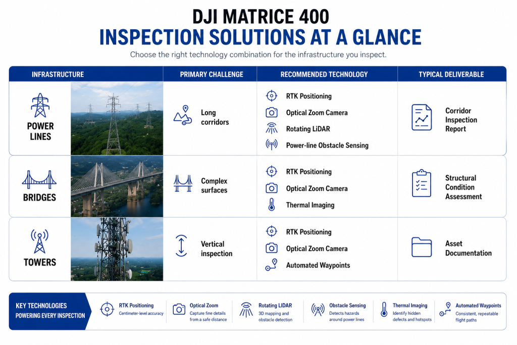
Power line inspections demand both efficiency and precision. Begin with a thorough pre-flight review by mapping the transmission corridor, confirming airspace permissions, checking weather conditions, and identifying potential sources of signal interference. RTK positioning enables repeatable flight paths, making it easier to compare inspection data over time and monitor asset condition.
Once the mission begins, automated waypoint flights allow operators to focus on image quality rather than aircraft control. The DJI Matrice 400 combines rotating LiDAR, integrated power-line obstacle sensing, and six-direction mmWave radar to navigate complex corridors while maintaining safe clearance from conductors. Optical zoom captures detailed images of insulators, connectors, and transmission hardware, while thermal imaging helps identify overheating components before failures occur. Throughout the mission, document vegetation encroachment, corrosion, damaged fittings, and other maintenance concerns to achieve complete corridor coverage in a single flight.
While power lines prioritize efficient corridor mapping, bridge inspections require a slower, more deliberate approach focused on structural detail and multiple viewing angles.
Power Line Inspection Tips Using the DJI Matrice 400
Power line inspections require a structured workflow to maximize safety and capture consistent data across long transmission corridors. Before takeoff, review the inspection route, identify potential obstacles, verify weather conditions, establish an RTK connection, and plan repeatable waypoint missions for consistent inspections.
During the mission, the DJI Matrice 400 can fly automated waypoint routes while maintaining a safe distance from energized assets. A high-resolution optical zoom camera captures detailed images of insulators, conductors, connectors, spacers, and tower hardware, while rotating LiDAR, mmWave radar, and intelligent obstacle sensing improve power line detection and obstacle awareness in complex environments. The live camera feed also enables operators to verify image quality and inspect critical components in real time.
After landing, review the collected data before leaving the site to confirm complete coverage. A standardized workflow supported by intelligent flight automation and advanced sensing technologies helps utilities improve inspection consistency, identify defects earlier, and plan maintenance more efficiently.
Bridge Inspection Best Practices
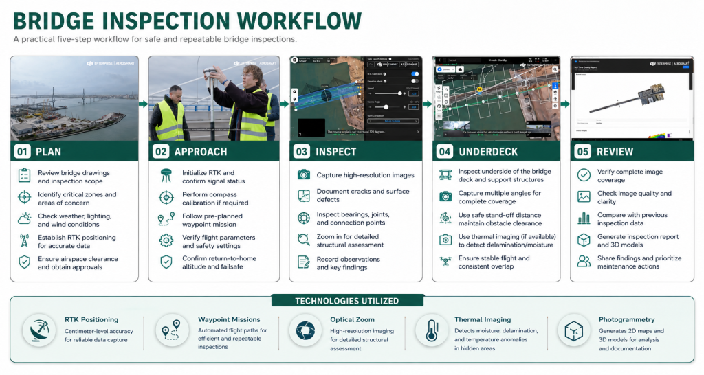
Bridge inspections require a slower, more deliberate approach than corridor surveys. Instead of covering long distances, operators must safely position the aircraft close to concrete and steel structures to capture fine structural details. Begin by establishing RTK positioning and planning a systematic flight path around the bridge. High-resolution optical imaging clearly documents expansion joints, concrete cracks, surface spalling, corrosion, and bearing conditions, while thermal imaging helps identify moisture intrusion, delamination, and other hidden defects that may not be visible to the naked eye.
Capture imagery from multiple oblique angles instead of relying solely on overhead views. Combined with overlapping images, this supports photogrammetric modeling, creating detailed records for condition assessment and future comparisons. Automated waypoint missions ensure consistent coverage of critical structural elements, while careful planning around weather and lighting minimizes shadows and glare that can conceal defects. The result is a comprehensive structural assessment that supports more informed maintenance decisions.
Tower inspections, however, introduce a different challenge, requiring precise vertical flight planning and consistent coverage from multiple elevations.
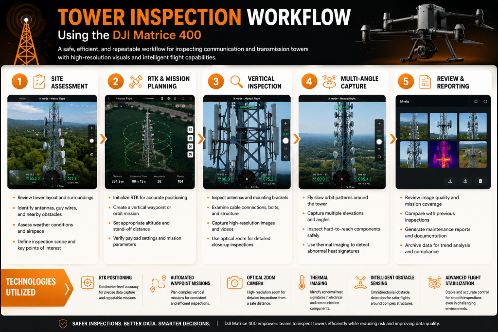
Tower Inspection Workflow Tips
Inspecting communication towers, transmission towers, and other vertical structures requires a different approach than corridor inspections. Before takeoff, review the tower layout, identify nearby obstacles such as guy wires or adjacent structures, establish an RTK connection, and plan a vertical waypoint or orbit mission. Careful mission planning helps maintain consistent standoff distances while capturing complete coverage from multiple elevations.
During the inspection, the DJI Matrice 400’s high-resolution optical zoom camera allows operators to examine antennas, mounting brackets, cable connections, bolts, insulators, and other critical components without climbing the structure. Flying slow, controlled orbit patterns around the tower provides multiple viewing angles, while intelligent obstacle sensing and advanced flight stabilization help maintain safe operations when working close to complex structures. Thermal imaging payloads can also be used, where applicable, to identify abnormal heat signatures in electrical equipment.
After the mission, review the collected imagery before leaving the site to confirm complete coverage. A repeatable inspection workflow makes it easier to compare historical data, identify developing defects, and support proactive maintenance planning.
General Best Practices for Every Infrastructure Survey
Regardless of the asset being inspected, following a consistent workflow helps improve data quality, operational safety, and mission efficiency. These best practices can help teams maximize every inspection with the DJI Matrice 400.
Before Takeoff
- Review weather and wind conditions.
- Assess the site for hazards and restricted areas.
- Establish an RTK connection for precise positioning.
- Select the appropriate payload based on the inspection objective.
- Verify batteries, sensors, and camera settings.
During the Mission
- Use automated waypoint missions whenever possible.
- Capture overlapping imagery for complete coverage.
- Maintain safe stand-off distances from structures.
- Monitor battery levels and aircraft status.
- Follow local aviation regulations throughout the flight.
Before Leaving the Site
- Review collected images and sensor data.
- Confirm that all critical assets have been documented.
- Re-fly any missed areas while still on site.
- Organize and back up inspection data.
- Prepare findings for reporting and long-term asset comparison.
Following a standardized inspection workflow reduces repeat site visits, improves consistency across inspections, and provides reliable data for maintenance planning and long-term asset management.
Conclusion
Successful infrastructure inspections depend on combining the right workflow with appropriate sensing technologies. No single configuration works for every asset, and rushing through mission planning often leads to incomplete data and costly repeat flights. The DJI Matrice 400 supports power line, bridge, and tower inspections through integrated RTK positioning, advanced omnidirectional obstacle sensing, extended flight endurance, and compatibility with enterprise imaging payloads. These capabilities enable teams to perform inspections more safely, consistently, and efficiently than traditional methods. Whether you are monitoring transmission corridors for seasonal damage, assessing bridge structural health, or documenting tower integrity at height, the platform adapts to your operational needs. The workflows outlined in this guide establish a foundation for systematic asset inspections that build reliable historical records and support data-driven maintenance decisions.
If your organization is looking to modernize its infrastructure inspection operations, Dynatech Innovations can help. Our specialists can recommend the right DJI Matrice 400 configuration, payloads, and deployment strategy based on your operational requirements, helping you maximize efficiency and inspection accuracy. Explore the DJI Matrice 400 solution or contact the Dynatech team to discuss the best setup for your next inspection project.