Are you ready to take your drone piloting skills to new heights? Whether you’re a seasoned aviator or just dipping your toes into the world of aerial exploration, understanding how to maximize the capabilities of your DJI drone is essential. That’s where professional flight planning software like UgCS comes into play.
In this blog, we’re embarking on a journey to explore the incredible benefits of UgCS and how it can revolutionize your drone operations. From enhancing mission success rates to boosting accuracy and operational efficiency, we’ll uncover the countless ways in which UgCS can elevate your drone flying experience.
Join us as we dive deep into the world of drone piloting, serving as your trusted guide to harnessing the full potential of your DJI drone with UgCS. Let’s soar to new heights together!

Benefits of Utilizing Professional Flight Planning Software
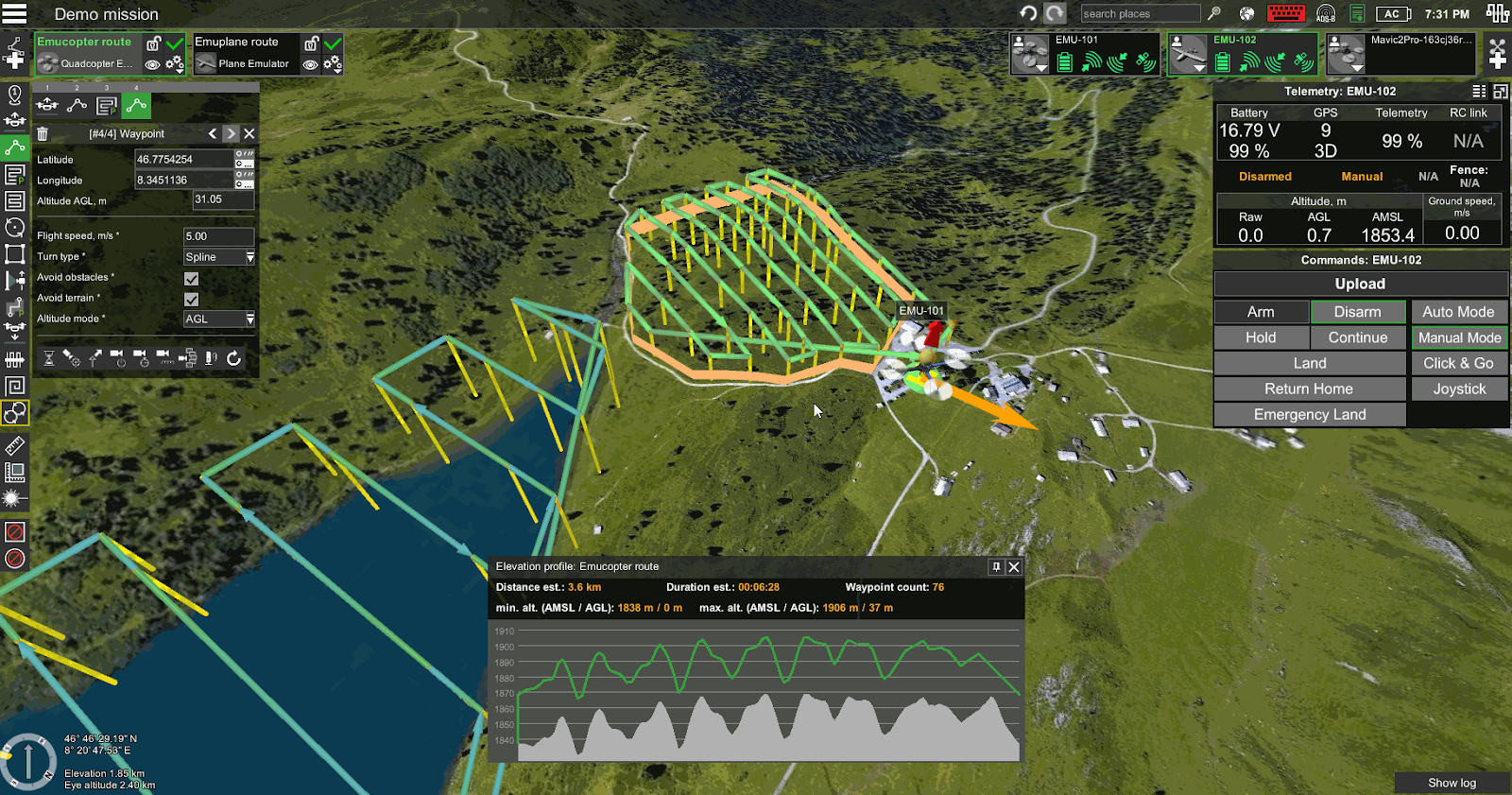
UgCS distinguishes itself as a comprehensive solution for drone pilots, offering a multitude of benefits that enhance operational efficiency and mission success. With its intuitive interface and robust features, UgCS enables users to effortlessly create basic routes while also catering to the demands of large-scale projects and intricate flight plans. The software’s full route customization capabilities provide unparalleled flexibility, allowing pilots to tailor their missions precisely to their needs. Moreover, UgCS boasts an impressive array of 12 flight planning tools, empowering users with versatility and adaptability in planning missions of varying complexities. From automatic route creation from file imports to the ability to preview multiple routes side-by-side, UgCS streamlines the planning process, saving time and optimizing workflow efficiency.
Furthermore, UgCS’s unlimited segments per route feature and specialized tools like the vertical scan tool and orbit flights elevate the precision and depth of aerial missions, enhancing the overall quality of data collection and analysis. With UgCS, drone pilots not only gain access to cutting-edge flight planning capabilities but also unlock a suite of powerful tools designed to elevate their capabilities and streamline their operations, making it an indispensable asset for both seasoned aviators and novice enthusiasts alike.
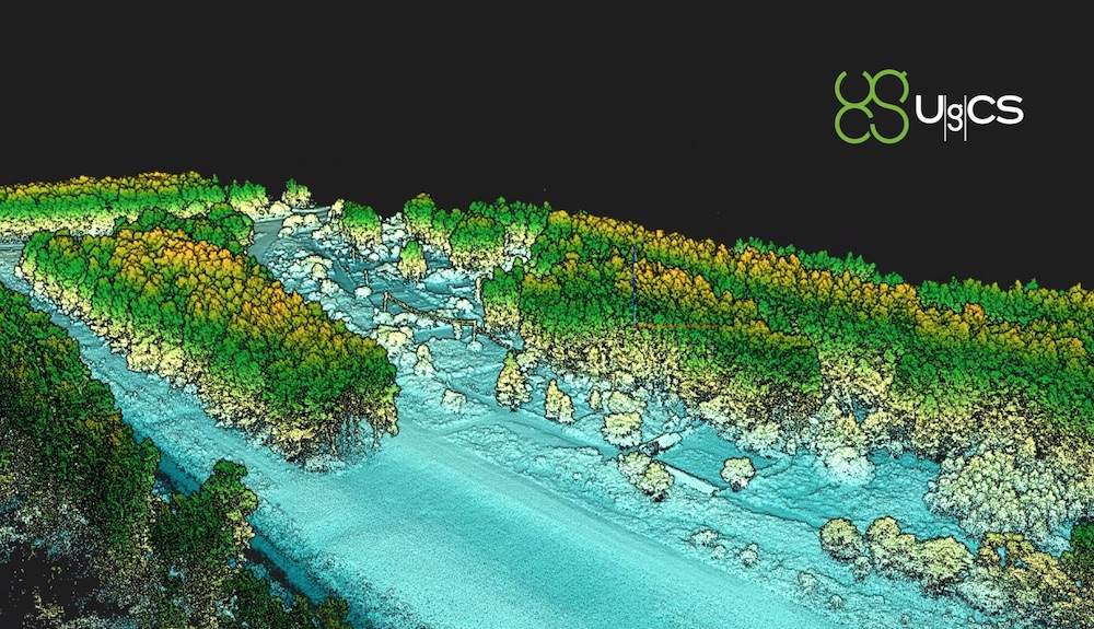
Securing Lucrative LiDAR Projects
For drone professionals aiming to penetrate the lucrative realm of LiDAR projects, mastering the intricacies of planning and executing these missions is paramount. With UgCS software at their disposal, pilots gain the capability to meticulously strategize and execute LiDAR missions tailored precisely to clients’ requirements, particularly in construction and land surveying domains. UgCS offers specialized features uniquely designed for LiDAR projects, equipping pilots with the tools necessary to not only secure but also successfully complete critical assignments. Setting oneself apart in this competitive landscape entails showcasing an adeptness in adapting to project-specific demands and providing innovative solutions that maximize the full potential of LiDAR technology.
Furthermore, by leveraging UgCS’s exclusive features such as DJI L1/L2 calibration, flight planning utilizing FOV angle, and customizable calibration patterns like Figure-8 and U-shape IMU, pilots can ensure unparalleled precision and accuracy in their missions. The software’s adjustable corner radius and loop corner turns further enhance maneuverability and optimize data collection efficiency. Notably, these advanced features are absent in DJI Pilot 2, underscoring UgCS’s superiority in meeting the specialized needs of LiDAR projects. Moreover, integrating drone flight tutorial content into service offerings adds substantial value for clients and peers alike, positioning drone professionals as trusted experts in their field.
Navigating New Heights: Unveiling the Vital Role of Terrain Following in Drone Operations
UgCS boasts a suite of advanced features that set it apart in the realm of drone flight planning, including Basic AGL terrain following and the innovative Smart AGL mode for flights over near-vertical slopes. These functionalities enable pilots to navigate challenging terrain with ease, ensuring precise and safe flights even in rugged environments. Additionally, UgCS offers an elevation profile preview feature, providing pilots with a comprehensive view of the terrain ahead to plan their missions with precision. With adjustable terrain following resolution, users have the flexibility to customize their flight parameters according to specific project requirements, further enhancing the software’s adaptability and utility in diverse operational scenarios.
Mastering the Skies: UgCS Soars Above as the Ultimate Flight Planning Companion
In conclusion, UgCS emerges as the clear frontrunner, offering a comprehensive suite of features tailored to meet the diverse needs of drone pilots across various industries. From its ability to save time through preplanning flights on large PC/Mac screens to its specialized tools for LiDAR projects, UgCS stands out as a versatile and powerful solution. Moreover, UgCS excels in terrain following capabilities, providing advanced features like Basic AGL terrain following, Smart AGL mode for flights over near-vertical slopes, and adjustable terrain following resolution, enabling precise and safe navigation even in challenging environments. These features not only enhance situational awareness and mission planning but also ensure reliable execution in any terrain. By integrating these cutting-edge features, UgCS empowers drone pilots to unlock new possibilities and navigate elevated terrain with confidence, ultimately leading to more efficient, safer, and successful missions.