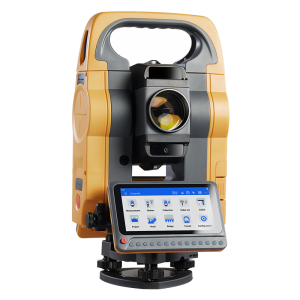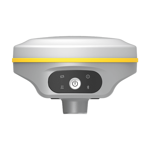
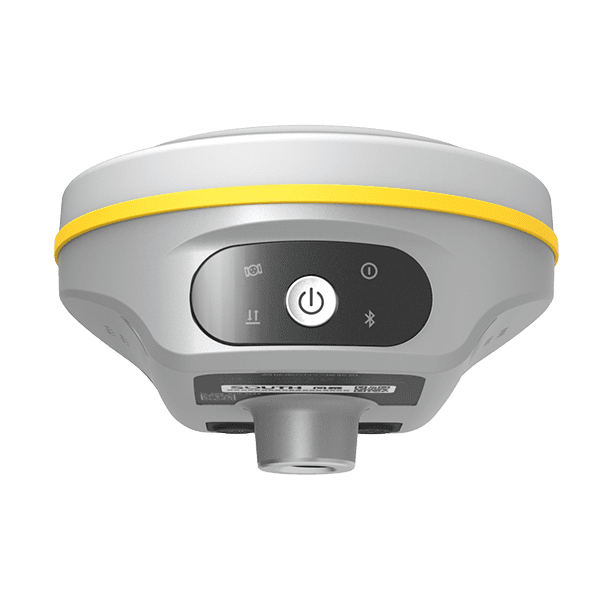
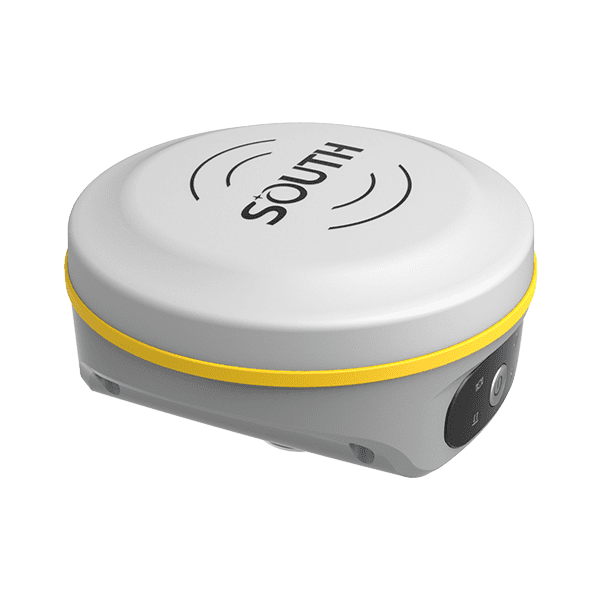
South G7Q
New miniaturized RTK receiver
- Up to 1598 Channels
- IP67 Waterproof & Dustproof
- Farlink Communications
- 15-Hour Long Battery Life
-
Description
Extraordinary GNSS….
The GNSS unit of G7Q is integrated with an advanced SoC which is a chip comes with the advantage of high integration and low power consumption, efficiently suppress the interference signals, and obtain higher quality observation data from satellite constellations.
Combines with powerful GNSS RTK engine with 1598 channels, and the new generation high sensitivity antenna, G7Q achieves centimeter precision in seconds while fully tracking GPS, GLONASS, BEIDOU, GALILEO and QZSS signals.

Brilliant design
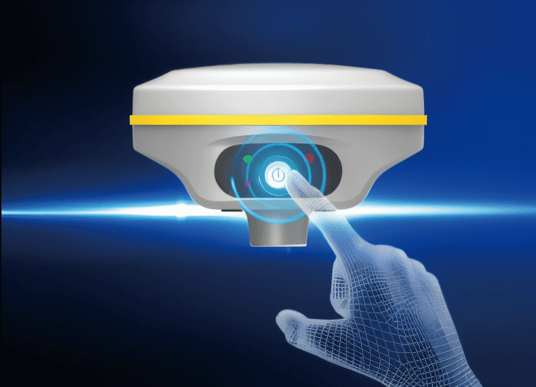
Single button boot design, one button evokes all RTK operations.
The body screen adopts a translucent high-strength panel, which has a stronger visual sense of technology. Plus four color indicator lights, common information is clear at a glance.
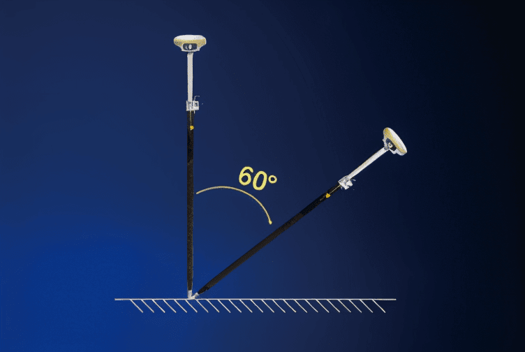
Smart unit of tilt measurement
An inbuilt high performance IMU automatic compensator which corrects the coordinates to the pole tip, that assists users quickly and accurately measure or stake out points at will without strict leveling the receiver, it helps surveyors boost productivity by 30 percent. Furthermore, the compensation is still available even though the fixed solution is lost at a short time, surveyors are able to continue the job after fixed solution recovers without initializing again for the IMU module. And the tilt angle range can achieve to 60°.
Unmatched connectivity
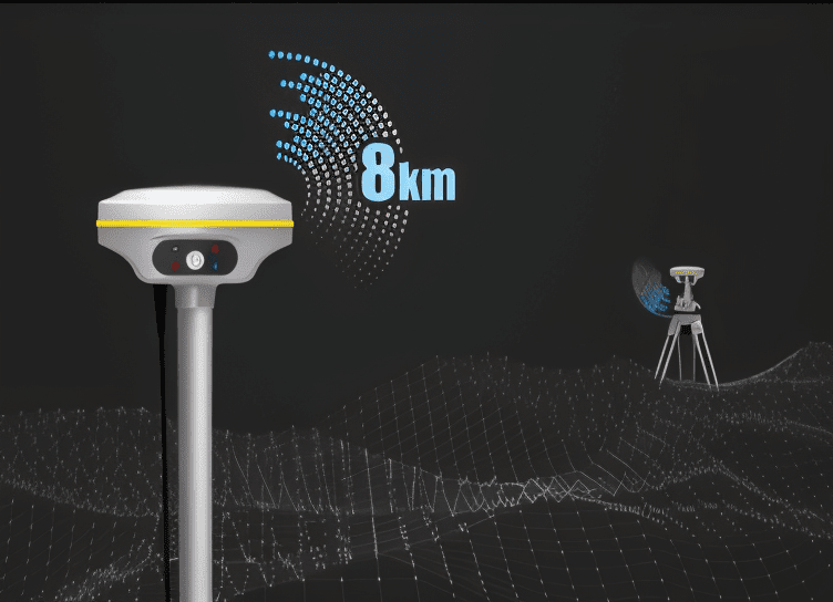
Built-in SOUTH self-developed digital radio, with an advanced protocol “Farlink”, makes G7Q achieve the typical working range as 8km. The transmission bandwidth of “Farlink” becomes large, and it increases the sensitivity of radio signal capture, which perfectly solves the problem of large data volume of multiple constellations transmission. And the power consumption can reduce about 60% in the same amount of data transmission compare to the traditional RTK.
Unlimited productivity
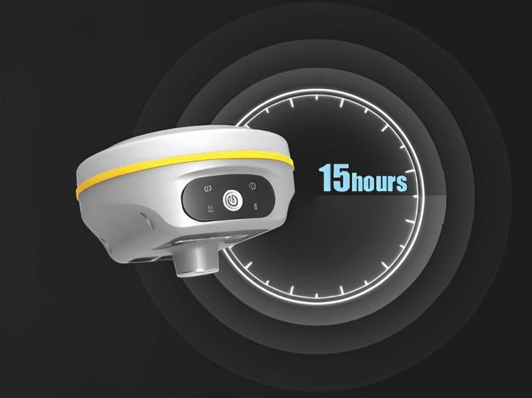
The new generation of SoC platform gives RTK more stable performance and lower power consumption. The built-in 6800mAh high-performance battery can support more than 15 hours of continuous operation. Featuring with a universal type-C interface, G7Q allows to charge the built-in batteries with a PD rapid charger, and support power supply from a power bank to ensure a full-day work.
Both internal memory and web interface are accessed by this type-C interface simultaneously without switching working mode for this port.
Specification
| GNSS Features | Channels | 1598 |
| GPS | L1, L1C, L2C, L2P, L5 | |
| GLONASS | L1C/A,L1P,L2C/A,L2P,L3 | |
| BDS | BDS-2: B1I, B2I, B3I, BDS-3: B1I, B3I, B1C, B2a, B2b* | |
| GALILEOS | E1, E5A, E5B, E6C, AltBOC* | |
| SBAS(WAAS/MSAS/EGNOS/GAGAN) | L1* | |
| IRNSS | L5* | |
| QZSS MSS L-Band (Reserve) |
L1, L2C, L5* | |
| Positioning output rate | 1Hz~20Hz | |
| Initialization time | < 10s | |
| Initialization reliability | > 99.99% | |
| Positioning Precision | Code differential GNSS positioning | Horizontal: 0.25 m + 1 ppm RMS Vertical: 0.50 m + 1 ppm RMS |
| GNSS static | Horizontal: 2.5 mm + 0.5 ppm RMS Vertical: 5 mm + 0.5 ppm RMS |
|
| Real-time kinematic (Baseline<30km) |
Horizontal: 8 mm + 1 ppm RMS Vertical: 15 mm + 1 ppm RMS |
|
| SBAS positioning | Typically < 5m 3DRMS | |
| RTK initialization time | 2 ~ 8s | |
| IMU tilt compensation | Additional horizontal pole tip uncertainty typically less than 10mm + 0.7 mm/° tilt down to 30° |
|
| IMU tilt angle | 0° ~ 60° | |
| Hardware Performance | Dimension | 135mm(W) ×135mm(L) × 83mm(H) |
| Weight | 907g (battery included) | |
| Material | Magnesium aluminum alloy shell | |
| Operating Temperature | -25℃ ~ +65℃ | |
| Storage Temperature | -40℃ ~ +80℃ | |
| Humidity | 100% Non-condensing | |
| Waterproof/Dustproof | IP67 standard, protected from long time immersion to depth of 1m IP67 standard, fully protected against blowing dust |
|
| Shock/Vibration | Withstand 2 meters pole drop onto the cement ground naturally |
|
| Power Supply | 6-28V DC, overvoltage protection | |
| Battery | Inbuilt 7.2V 6800mAh rechargeable, Li-ion battery |
|
| Battery Life | 15h (Rover Bluetooth mode) | |
| Communications | I/O Port | 5-PIN LEMO external power port + RS232 Type-C interface (charge, OTG, data transfer to PC or phone, Ethernet) 1 UHF antenna interface |
| Internal UHF | 2W radio, receive and transmit, radio router and radio repeater | |
| Frequency range | 410 – 470MHz | |
| Communication protocol | Farlink, Trimtalk450s, SOUTH, HUACE, Hi-target, Satel | |
| Communication range | Typically 8km with Farlink protocol | |
| Bluetooth | Bluetooth 3.0/4.1 standard, Bluetooth 2.1 + EDR | |
| NFC Communication | Realizing close range (shorter than 10cm) automatic pair between receiver and controller (controller requires NFC wireless communication module else) |
|
| WIFI | Modem | 802.11 b/g standard |
| WIFI Hotspot | Receiver broadcasts its hotspot form web UI accessing with any mobile terminals | |
| WIFI Datalink | Receiver can transmit and receive correction data stream via WiFi datalink | |
| Data Storage/Transmission | Storage | 4GB SSD internal storage standard, extendable up to 64GB automatic cycle storage (The earliest data files will be removed automatically while the memory is not enough) support external USB storage the customizable sample interval is up to 20Hz |
| Data Transmission | Plug and play mode of USB data transmission supports FTP/HTTP data download | |
| Data Format | Static data format: STH, Rinex2.01, Rinex3.02 and etc. Differential data format: RTCM 2.1, RTCM 2.3, RTCM 3.0, RTCM 3.1, RTCM 3.2 GPS output data format: NMEA 0183, PJK plane coordinate, Binary code Network model support: VRS, FKP, MAC, fully support NTRIP protocol |
|
| Sensors | Electronic bubble | Controller software can display electronic bubble, checking leveling status of the carbon pole in real-time |
| IMU | Built-in IMU module, calibration-free and immue to magnetic interference | |
| Thermometer | Built-in thermometer sensor, adopting intelligent temperature control technology, monitoring and adjusting the receiver temperature | |
| User Interaction | Operating system | Linux |
| Buttons | Single button | |
| Indicators | 4 LED indicators (satellite, Datalink, Bluetooth, Power) | |
| Web Interaction | With the access of the internal web interface management via WiFi or USB connection, users are able to monitor the receiver status and change the configurations freely | |
| Voice Guidance | It provides status and operation voice guidance, and supports Chinese/English/ Korean/Spanish/Portuguese/Russian/Turkish | |
| Secondary Development | Provides secondary development package, and opens the OpenSIC observation data format and interaction interface definition | |
| Cloud Service | The powerful cloud platform provides online services like remote manage, firmware update, online register and etc. |
Items marked with * will be upgraded along with the update of assigned firmware
The data comes from the SOUTH GNSS Product Laboratory, and the specific situation is subject to local actual usage.
1.Actual battery life can vary depending on usage patterns and other factors. The listed parameter was obtained under controlled testing conditions.
Related products
-
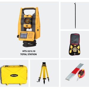
Hi-Target HTS-720 Android Total Station (Full Set)
AED13,400.00 VAT Excl -
Hi-Target HTS 521L10 Optical Total Station (Full Set)
AED11,600.00 VAT Excl -